The historical aerial photographs, especially those which date back earlier than the 1950’s, are an excellent source for reconstructing the evolution of the landscapes and discovering their archaeological potential.
Even though in northern Maremma the first hydarulic reclamations, which took place by drying up or backfilling, began at the end of the 18th century, it was the agrarian reform of 1950 that caused the most radical changes to the landscape. The policy of land reclamation led to the shattering of the preivious land division system (latifundium), the consequent spreading of the scattered settlement model and the total geometrization of the rural space. Moreover, agricultural mechanization, whose slow and gradual development began in the 1920’s and then exploded in the 1950s, and the specialization of market production (vines, fruit trees and cereals) have completely changed the agricoltural working system.
By anaysing the photographs taken before these profound changes enables the acquisition of valuable information about the historical landscape evolution.
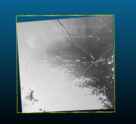
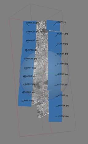
The frames examined for the purpose of the ERC nEU-Med project were taken by the IGM (Istituto Geografico Militare) during the flights of 1938 and 1940-41 and cover the whole extension of the project’s territory. These frames have photogrammetric properties, and can be used to obtain a stereoscopic view of the territory (three-dimensional effect) and exact measurements of reality. With analog photogrammetry, the 3D vision is appreciable through the use of the stereoscope, when two frames are overlapping for at least 60%.
The innovative approach of the research activity developed by nEU-Med is the use of historical frames within recently developed digital photogrammetry software, to obtain digital terrain models (point clouds) of the very landscape photographed in the years ’38-’41 (Fig.1).
These models carry information on the land morphology of the past which can be compared with the land morphology of today highlighting those changes that are the result of intense agricultural activities and industrialization occurred in the last 80 years.
The method will be used to assess the impact of topographic, natural and anthropic changes on the archaeological record. For example, it’s possible to measure the variation of the soil level in the presence of the sites that are certified but not yet excavated, or to assess the dynamics of dispersion of the archaeological finds retrieved during fieldwalking (Fig.2).